- 75% of Earth’s volcanoes are under water, but knowledge of submarine volcanoes remains poor.
- The Hunga Tonga Hunga Ha’apai 2022 eruption injected a huge volume of water into the atmosphere.
- Using satellite-derived gravity data, Professor Román Alvarez at the National Autonomous University of Mexico revealed that, instead of a single conduit, magma pockets are distributed over a large area of the shallow crust.
- He believes that these pockets erupted simultaneously, causing huge-scale interaction with seawater.
- The results of this study have implications for hazard prediction and management of submarine volcanoes like the Hunga Tonga Hunga Ha’apai.
The vast majority of Earth’s volcanoes – 75% – lie beneath the waves. Despite this, compared with their terrestrial counterparts, our knowledge of undersea volcanoes remains poor. The inaccessibility of the Earth’s interior is a challenge for volcanologists at the best of times; when further hidden by the ocean column, the job becomes exponentially harder, with direct observations and data collection of subsea volcanic interiors a major challenge.

While the serious risks associated with subsea volcanism have long been recognised by volcanologists, they became apparent to a global audience in January 2022, when the Hunga Tonga Hunga Ha’apai (HTHH) volcano sent a plume of ash to an altitude of 57 km. This was the first-ever observation of a mesospheric volcanic ash plume. During the event, nearly 10 km2 of the seafloor and the flanks of the volcano were covered by material flowing away from the edifice, including seafloor sediments that were swept along with the erupted material. Most of this material came to rest within a 20 km radius of the volcano; the effects on marine ecosystems were devastating. Moreover, the flows cut communication cables between the Kingdom of Tonga and the rest of the world, significantly hampering the disaster response in the days and weeks following the eruption. It was the largest eruption of an undersea volcano for 150 years, the largest ever to be recorded by modern instruments, and one of the most powerful volcanic events of recent centuries.
Tectonic setting of HTHH
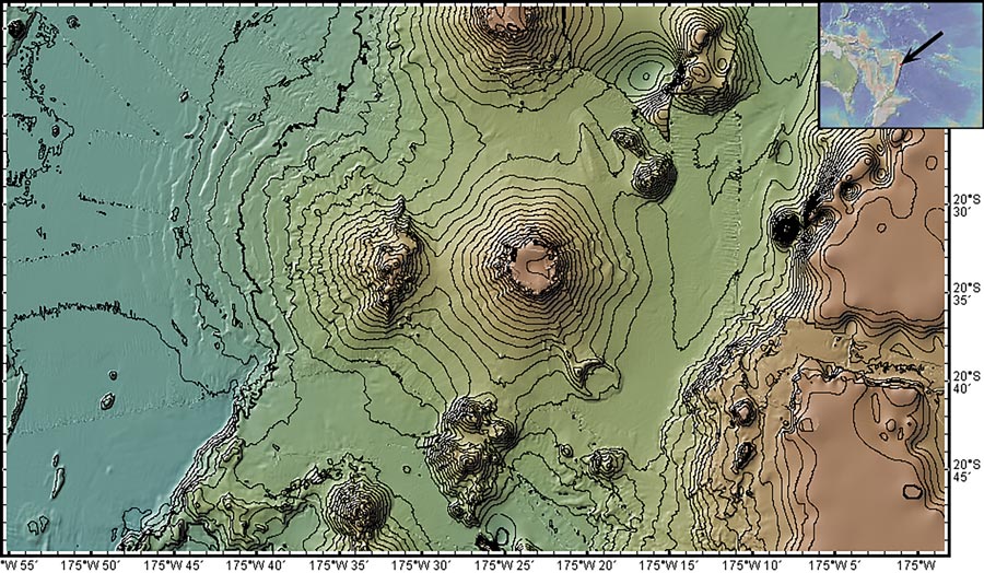
HTHH is located along the Tonga–Kermadec Ridge, formed by the subduction of the Pacific Plate beneath the Tonga and Kermadec micro-plates; that is, as the plates converge, the Pacific Plate is slipping beneath the Tonga and Kermadec micro-plates. As one of the most rapid subduction zones on the planet (> 20 cm per year), volcanic activity in this region is common. Subduction along the Tonga–Kermadec arc is also relatively usual because the tectonic plates involved are all oceanic.
Compared with their terrestrial counterparts, our knowledge of undersea volcanoes remains poor.
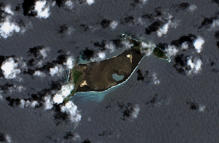
The result is a plethora of submarine volcanoes. Prior to the 2022 eruption, only two small parts of HTHH had formed above the water despite a base-to-summit height of 1,400 m. During the 2022 HTHH eruption, the above-sea portion of the island was completely destroyed; along with ash and other volcanic gases, a huge volume of water was injected into the atmosphere, equating to 10% of the global atmospheric water budget.
At the National Autonomous University of Mexico, Professor Román Alvarez has set out to better understand the structure of the plumbing system beneath HTHH, with the aim of explaining the enormous volume of water transferred from the ocean to the atmosphere during this event.

Photo Credit: Contains modified Copernicus Sentinel data 2021, CC BY-SA 3.0 IGO, via Wikimedia Commons
Probing Earth’s interior
Alvarez turned to satellite technology to collect data about the structure of HTHH in the years leading up to the 2022 eruption. High-resolution (pixel size of ~220 m) satellite-derived gravity data were subjected to 3D gravity inversions; that is, the data were processed so that gravity variations could be analysed in a 3D volume. Although the changes are imperceptible to humans, gravity is not constant; the force of gravity experienced by a given object is a function of many factors, including its density. Volcanic plumbing systems contain a variety of materials of different densities (eg, rocks of different compositions, molten magma, gases, etc); the denser the material, the stronger the force of gravity. As such, 3D inversions of gravity data from volcanoes can create a 3D picture of the sub-surface structure, with low-gravity regions associated with magma transport and storage.

By following this process, Alvarez found an unexpected result. Instead of a single dominant magma conduit, the shallow crust of HTHH contained a wide distribution of low-density material, which he attributed to multiple conduits feeding a shallow magma transport network. The model showed a principal conduit descending into the crust (towards the deep magma storage region) from a depth of ~6 km. Above this, the conduit bifurcated to form two main branches, those extending to the north-western and south-eastern sides of the volcano. Further bifurcations occurred in the shallow crust, and low-density anomalies extended into the uppermost surface layer (the top few hundred metres). The total area covered by these two regions was approximately 26 km2.
Instead of a single dominant magma conduit, the shallow crust of HTHH contained a wide distribution of low-density material.
Interestingly, reports from the 2009 eruption of HTHH suggested that material was ejected from multiple vents. This supports Alvarez’s findings of multiple shallow pockets of magma in the near-surface region. Alvarez argues that if, in 2022, magma had ascended to the surface in pockets spread over 26 km2, the resulting interaction with seawater would have been huge. This suggestion is consistent with the observations of the 2022 eruption, including the high explosivity caused by magma–water interaction (when liquid water encounters magma, it flashes to steam, causing sudden and violent explosions) and the huge volume of water injected into the atmosphere.
As of yet, there is insufficient satellite gravity data over the region to determine how the magmatic plumbing system at HTHH was changed by the 2022 eruption. However, the results provide an important baseline for understanding the evolution of the volcano in the future. In the coming years, as more satellite-based gravity data become available or new marine gravity surveys are performed, Alvarez will be able to determine changes in the magma transport network beneath the volcano, with significant implications for hazard planning.

Photo Credit: Japan Meteorological Agency, CC BY 4.0 DEED, via Wikimedia Commons
What inspired you to conduct this research?
The magnitude of the explosive activity of the HTHH volcano and the lack of information about its internal structure. The availability of high-resolution, satellite-derived gravity measurements allowed the application of the 3D inversion protocol to analyse internal density distribution.
How long will it take before there is sufficient data to determine the current structure of the plumbing system at HTHH?
This depends on several factors that are outside my control. The gravity data reported here corresponds to the structure of the volcano before the 2022 eruption, constituting a baseline for future changes induced by the 2022 and future eruptions. How fast new high-resolution data or new marine gravity surveys will be available is beyond my power. The next step will be to perform a new analysis on a similar, nearby Tofua volcano, 93 km NNE of HTHH volcano to compare characteristics.
How accurate is satellite-derived gravity data compared with ground-based measurements?
Differences at a given ground station may differ up to 5 %. However, measurements are required over the whole study area, not only over a given station. To acquire data on the ground is a slow, non-uniform, expensive process since usually access is limited to dirt roads and trails. In the case of active volcanoes, it is also risky; furthermore, once acquired and corrected, ground data is usually interpolated to generate a uniform mesh, with the potential introduction of artifacts. Satellite-derived gravity data is freely available and uniformly displayed with a variable mesh separation that may go down to ~200 m. The possibility of discerning internal structures in volcanoes and other geologic structures is directly proportional to the mesh separation used. Hence our preference for satellite-derived measurements.
Do you have plans to apply this technique to any other submarine volcanoes?
Indeed, as mentioned above we are planning to examine Tofua volcano to continue learning about submarine volcanoes. We are also scheduling Everman Volcano in Socorro Island, Mexico. A partial list of already reported, or in process, terrestrial volcanoes with the same technique is: Nevado de Toluca, Popocatépetl, Iztaccíhuatl, Tancíatro, Colima, and Paricutín volcanoes in Mexico, and Nevado del Ruíz in Colombia.


